Settlement network thematic group
Over the past decade, our understanding of Bronze Age settlement networks and structures in Hungary has undergone a significant transformation in several regions. Previous research had primarily focused on the domestic architecture of central settlements, prompting us to investigate the economic and social life of outlying settlements situated around these central settlements.
Micro-regional research
Our research team analyses tThe settlement history of the first thousand years of the Bronze Age and its transformation will be analysed in several micro-regions, incorporating the research carried out in recent years in the micro-regional sample areas of the Momentum Mobility Research Group. In the regions, we will carry out multi-level site reconnaissance as far as possible, including extensive and intensive field surveys, geophysical measurements, aerial and drone photos, as well as soil and environmental research.
- In Central Hungary, two major regions on the right and left banks of the Danube will be investigated. These are the Benta River valley, encompassing the area of today’s Százhalombatta, and the Zsámbék basin on the right bank of the Danube, while. Additionally, the Kakucs region and the Tápió Valley will be examined on the left bank of the Danube,
- On the northern edge of the Great Hungarian Plain the regionsites of Füzesabony and Tiszafüred,
- in the vicinity of Lake Fertő in the Nagycenk area,
- in the valley of the Séd stream to the east of Veszprém.
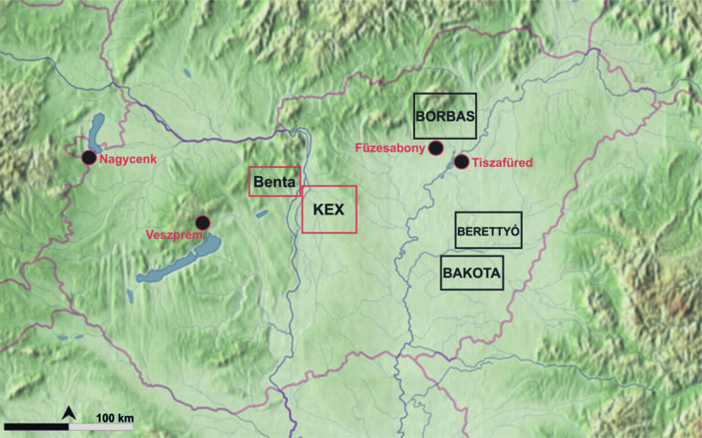
Bronze Age micro-regional projects in Hungary (marked in black) and the sample areas of the Momentum Mobility and Momentum Bases research group (marked in red)
Thematic database of Bronze Age (2500–1500 BC) micro-regional settlement networks in Hungary
The results of the studies carried out so far in the project will play an important role in the design and optimisation of the thematic database of Hungarian Bronze Age (2500–1500 BC) microregional settlement networks. In order to ensure the long-term preservation of the data, the collection and analysis of the data in a digital database will allow the creation of settlement models that consider the site networks of the individual regions and their temporal and spatial dynamics. This will facilitate the reconstruction of the socio-economic relations of prehistory.
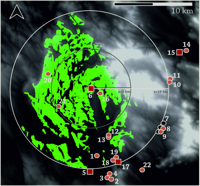
Magnetometer survey of Kakucs-Turján mögött site (Jaeger et al. 2018)
Models – regional, supra-regional and diachronic studies
The aim is to investigate the broader relationships between settlement hierarchies and spatial organisation at the Carpathian Basin level, based on published data. The identification of larger regional, supra-regional structures and central places will also be carried out on the basis of selected indicators, using the conclusions drawn from the analysis of the settlement network of the regions studied in the framework of the project. The network of settlements identified in this way, with different levels of central function, will not only assist in a more comprehensive understanding of the role of the regions studied in the project, but will also be useful for identifying actively used raw material resources, for studying the trade in raw materials, and for long-term diachronic analyses.
Visibility analysis from Budajenő-Hegyi-szántók site (Szabó 2023)
Our relevant works on the topic:
- Dani, János – P. Fischl, Klára – Kulcsár, Gabriella – Szeverényi, Vajk – Kiss, Viktória: Dividing space, dividing society: fortified settlements in the Carpathian Basin (c. 2300–1500 BC). In: Meller, Harald – Friedrich, Susanne – Küßner, Mario – Stäuble, Harald – Risch, Roberto (Hrsg.): Siedlungsarchäologie des Endneolithikums und der frühen Bronzezezeit – Late Neolithic and Early Bronze Age Settlement Archaeology. 11. Mitteldeutscher Archäologentag vom 18. bis 20. Oktober 2018 in Halle (Saale) – 11th Archaeological Conference of Central Germany October 18–20, 2018 in Halle (Saale). Tagungen des Landesmuseums für Vorgeschichte Halle 20. Halle (Saale): Landesamt für Denkmalpflege und Archäologie Sachsen-Anhalt. (2019) 851–868.
- Jaeger, Mateusz – Kulcsár, Gabriella – Taylor, Nicole – Staniuk, Robert (eds): Kakucs-Turján: Middle Bronze Age multi-layered fortified settlement in Central Hungary. Kakucs-Turján I – Studien zur Archäologie in Ostmitteleuropa 18. Bonn: Dr. Rudolf Habelt GmbH. (2018) 241 p.
- Kiss, Viktória – Kulcsár, Gabriella: ‘Europe without walls’: new directions of Bronze Age research in Hungary. In: Šabatová, Klára – Dietrich, Laura – Dietrich, Oliver – Harding, Anthony – Kiss, Viktória (eds): Bringing Down the Iron Curtain, Paradigmatic Change in Research on the Bronze Age in Central and Eastern Europe? Oxford: Archaeopress. (2020) 129–137.
- Melis, Eszter: Research Questions Regarding the Early and Middle Bronze Age in North-Western Transdanubia (Hungary). Some problems on the research of the Middle Bronze Age in North-western Transdanubia. In: Kulcsár, Gabriella – V. Szabó, Gábor – Kiss, Viktória – Váczi Gábor (eds): State of the Hungarian Bronze Age Research: Proceedings of the conference held between 17th and 18th of December 2014. Ősrégészeti Tanulmányok / Prehistoric Studies II. Budapest: HAS RCH, Institute of Archaeology. (2017) 13–28.
- Szathmári, Ildikó – Guba, Szilvia – Kulcsár, Gabriella – Serlegi, Gábor – Vágvölgyi, Bence – Kiss, Viktória: Füzesabony-Öregdomb Bronze Age Tell Settlement – New Insights on the Settlement Structure. In: P. Fischl, Klára – Kienlin, Tobias L. (eds): Beyond Divides – The Otomani-Füzesabony Phenomenon. Current Approaches to Settlement and Burial in the North-eastern Carpathian Basin and Adjacent Areas. Universitätsforschungen zur prähistorischen Archäologie 345. Bonn, Dr. Rudolf Habelt GmbH. (2019) 351–368.