Following the Tumuli: Bronze Age Research in the Lake Fertő/Neusiedl Region Supported by a New NRDI STARTING Grant

In autumn 2023, a joint research project was launched by the MTA–ELTE HTK Momentum BASES Research Group and the Sopron Museum to investigate Early and Middle Bronze Age (c. 2500–1500 BC) settlement patterns in the Lake Fertő/Neusiedl region. The rich cemeteries and hilltop settlements of this period represent an important link with the western regions of Central Europe, while also providing valuable evidence for social organisation and hierarchy. More information about our previous research is available on the websites of our institute and research group, as well as on the museum’s Facebook page.

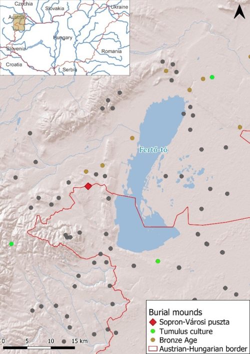
Since 2026, Bronze Age research in the region has gained new momentum through the support of the NRDI STARTING project Forging Communities, Emerging Power: Social Dynamics in Bronze Age Northwestern Carpathian Basin between 2200 and 1400 BC (STARTING 152650, 2026–2029, PI: Eszter Melis). Focusing on the emergence of social inequalities, the project will include comprehensive bioarchaeological investigations of the Early and Middle Bronze Age burials from Nagycenk, provenance analyses of a large number of copper and bronze artefacts, and, in addition, non-invasive surveys of the Bronze Age burial mounds in the region. The surroundings of Lake Fertő/Neusiedl represent not only the westernmost occurrence of steppe vegetation but also the westernmost distribution zone of Late Copper Age and Early Bronze Age kurgans (Ruttkay 2002). The tradition of constructing burial mounds continued throughout later archaeological periods, making the lake region an exceptional landscape for investigating long-term funerary traditions.

Distribution of burial mounds in the Lake Fertő/Neusiedl region (prepared by Eszter Melis based on Kaus 2006 and the National Registry of Archaeological Sites in Hungary)


The new NRDI STARTING project builds upon archaeological finds, excavation records from previous investigations, and the results of an airborne laser scanning (ALS) survey carried out in 2022 with the support of our institute. Covering a total area of 120 km² at a resolution of 25–50 cm, the ALS dataset provides the basis for targeted investigations of selected archaeological sites and their surrounding landscapes.

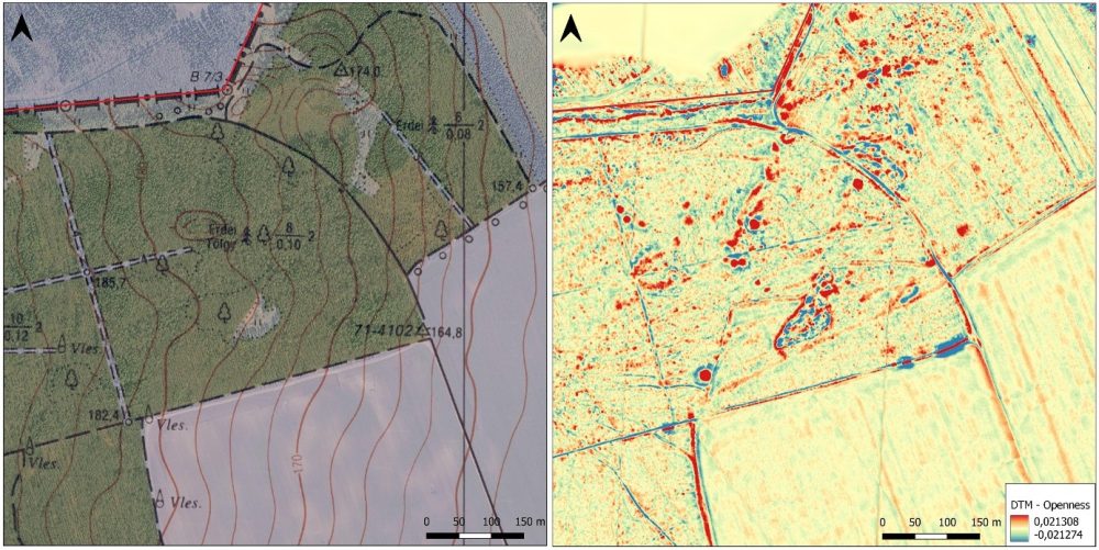
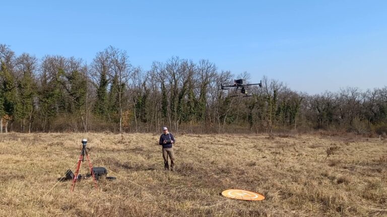
Thanks to our collaboration with János Mészáros (Institute for Soil Sciences, HUN-REN Centre for Agricultural Research), we have also been able to produce digital terrain models generated from UAV-based laser scanning (ULS) point clouds with a resolution of at least 10 cm. Surveys conducted at three sites, covering nearly 400 hectares with a ground point density of 130–150 points/m², have enabled the creation of terrain models far more detailed than those previously available, revealing surface traces of archaeological features only a few centimetres high.

Fieldwork using a DJI M350 UAV equipped with an L1 laser scanner, March 2026 (photo: Eszter Melis)


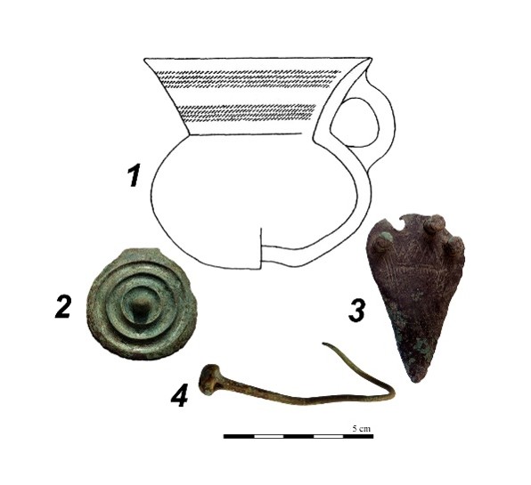
The first results from the investigations at the Sopron-Városi-puszta site were presented in a poster at the international conference A World in Motion in late April 2026 (Melis, Eszter – Berta, Adrián – Ekrik, Ákos – Mészáros, János – Mrenka, Attila: Mapping the Tumuli: New Perspectives on Late Middle Bronze Age Barrows in the Lake Fertő Region [Western Hungary]). Located in a landscape consisting of both woodland and cultivated fields, the site contains burial mounds that are clearly visible in the forested areas and can also be identified in the ALS data. Based on finds from earlier excavations and more recent metal-detector surveys, these barrows can be dated to the end of the Middle Bronze Age.

Middle Bronze Age finds from Sopron-Városi-puszta (1. Sopron Museum inv. no. 54.66.1; Benkovsky-Pivovarová et al. 1988, Fig. 1.1; 2. Sopron Museum inv. no. 2024.1.4.6, photo: Attila Mrenka; 3. Sopron Museum inv. no. 2019.1.41, photo: Krisztina Balassa, in Mrenka 2022, Pl. 2; 4. Sopron Museum, photo: Krisztina Balassa)


The initial ALS survey identified 30 regular circular elevations, ranging between 10 and 30 m in diameter, within an area of approximately 45 hectares. The higher-resolution ULS survey suggests the presence of two additional barrows, while in one case the extent of a previously identified mound appears to be larger than originally assumed. In contrast, on the cultivated part of the site, the surface traces of the barrows have been completely erased by ploughing.

To investigate this cultivated area, a magnetic survey was carried out across 14 hectares using a SENSYS MAGNETO® MXPDA magnetometer mounted on a five-sensor pushcart system. The processing and evaluation of the data are currently underway. Preliminary results indicate the presence of four circular ditches with diameters of approximately 15–20 m, suggesting that the barrow cemetery extended further to the south and east than previously recognised.

Detail of the Sopron-Városi-puszta site shown on a topographic map combined with Google satellite imagery and on the digital terrain model generated from the ULS survey (higher elevations are shown in red and lower elevations in blue; prepared by Eszter Melis)

The magnetometer survey of the barrow field will continue in order to determine its full extent. In addition, we plan to investigate the internal structure of selected barrows using further geophysical techniques, including ground-penetrating radar (GPR) and electromagnetic induction (EMI). We will present the new NRDI STARTING project in more detail in an upcoming post.

The fieldwork carried out in March 2026 involved Ákos Ekrik and Eszter Melis (ELTE Research Centre for the Humanities, Institute of Archaeology) and János Mészáros (Institute for Soil Sciences, HUN-REN Centre for Agricultural Research).

References

Benkovsky-Pivovarová, Z.–Gömöri, J.–Kaus, K. 1988: Az álzsinegdíszes (Litzen-) kerámia kultúrájához tartozó sírleletek Nyugat-Magyarországon és Kelet-Ausztriában. Arrabona 24–25 (1988) 4–19.

Kaus, K. 2006: Urgeschichtliche Grabhügel im Burgenland und in Westungarn. WAB 114. Eisenstadt, 23 – 36.

Melis, E.–Berta, A.–Ekrik, Á.–Mészáros, J.–Mrenka, A. 2026: Mapping the Tumuli: New Perspectives on Late Middle Bronze Age Barrows in the Lake Fertő Region (Western Hungary). In:  Fülöp, K. – Kulcsár, G. – Szabó, N. – Szigeti, A. (szerk.) A World in Motion: Between Tradition and Transformation in the Tumulus Culture along the Danube. International Conference Budapest, Hungary 22–24 April 2026, Abstracts. Budapest, 110–111. DOI: 10.62150/WiM.2026

Mrenka A. 2022: Bronzkori leletek Sopron környéki terepbejárásokból. Arrabona 60 (2022) 9–33.

Ruttkay, E. 2002: Das endneolithische Hügelgrab von Neusiedl am See, Burgenland. Zweite Vorlage. Teil 1 – Die Fazies Neusiedl. Budapest Régiségei 36 (2002) 145–170.
Related news