New Results from the Research of Tápióbicske–Várhegy and Kalapos-hegy
The Bronze Age history of the Tápió region has long been a focus of archaeological research as several fortified hilltop settlements are known near one another, outlining a densely inhabited and intensively utilized landscape. The terrain, characterized by hills, watercourses, and small valleys, provided favourable conditions for settlement establishment, many of which remain readily identifiable today. On the outskirts of Tápióbicske, two neighbouring elevations, Várhegy and Kalapos-hegy, rise prominently above the surrounding landscape. Traditionally, archaeological research has regarded them as two separate sites, however, based on their geographical setting and the results of recent investigations, it is conceivable that they once formed part of a single, extensive Bronze Age settlement. Although the sites have been known since the nineteenth century, our understanding of their structure, extent, and relationship to surrounding sites has remained limited. Research conducted in recent years has significantly expanded our knowledge of the region. An important starting point for these investigations was the OTKA research project led by Zsuzsa Miklós, which was based on the analysis of aerial photographs.
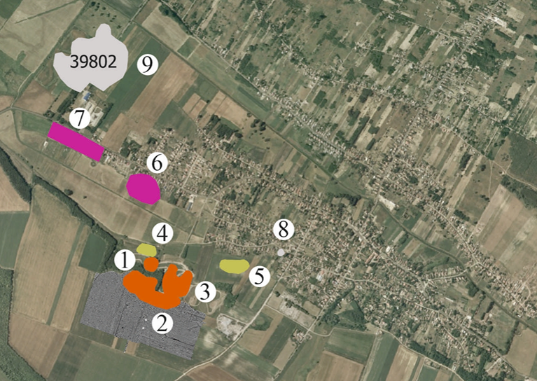
Middle Bronze Age Sites in the Territory of Tápióbicske. 1: Tápióbicske-Kalapos-hegy, 2: Tápióbicske-Várhegy, 3: Tápióbicske-Várhegy-agyagbánya, 4: Tápióbicske 13. lh, 5: Tápióbicske 14. lh., 6: Tápióbicske-Rákóczi út 208., 7: Tápióbicske-Rákóczi út 234–250., 8: Tápióbicske-Kossuth Lajos u. 172., 9: Tápióbicske-Tökös-kert, 10: Tápióbicske-Sertéstelep, 11: Tápióbicske-Fekete-föld, 12: Tápióbicske-Sertéslegelő, 13: Tápiószentmárton-Hatvani-hegy, 14: Tápiószentmárton-Öreghegy (Reference : MIKLÓS 2006; Magyar Nemzeti Múzeum Régészeti Adatbázis, https://archeodatabase.hnm.hu/).
Tápióbicske occupies a special place in the history of the Tápió Valley. Several archaeological sites located within the administrative territory of the settlement can be associated with the Early and Middle Bronze Age, particularly with the Hatvan and Vatya cultures. Previous rescue excavations and field surveys have revealed traces of settlements, burials, as well as bronze and gold artefacts. Of particular importance is a Bronze Age gold armlet that entered the collection of the Hungarian National Museum in 2016. This exceptional find provides valuable insight into the social relations of the period and serves as an important indicator of status-related material culture and prestige display among local communities.
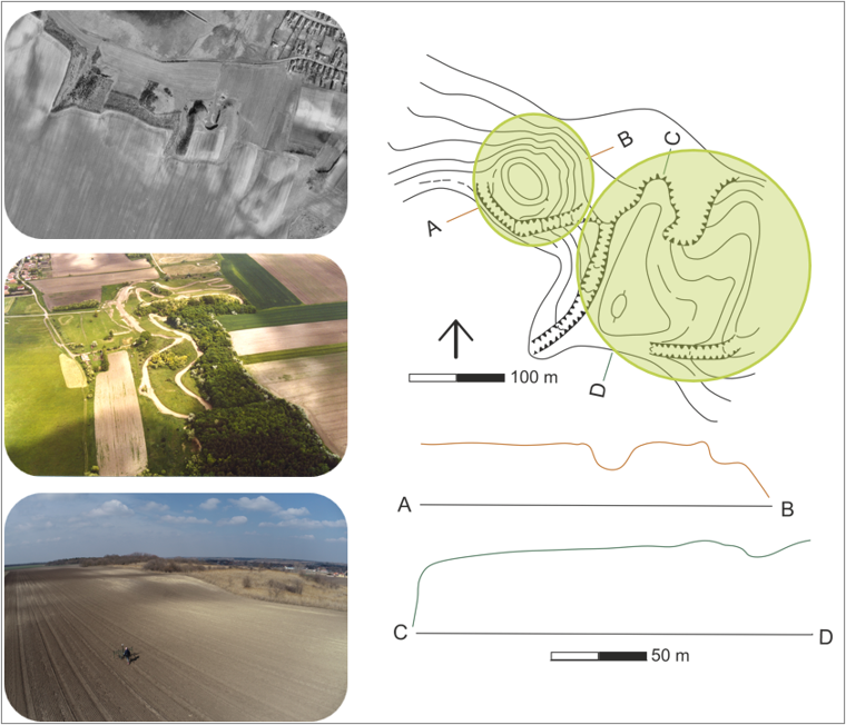
Changes in the site over the decades documented by satellite imagery, aerial photography, and drone surveys, together with the topographic setting of the sites based on the survey of Zsuzsa Miklós (after Kulcsár et al., Őskori erődített települések Közép-Magyarországon (Pest megye), and Szabó et al., Complex Settlement Analysis of a Middle Bronze Age Site near Tápióbicske, forthcoming).
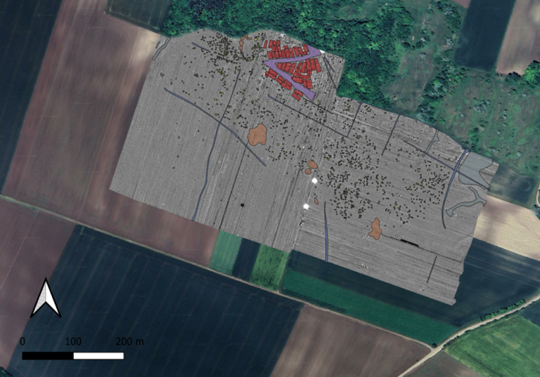
A new phase of research began in 2016, when members of the Institute of Archaeology, ELTE RCH began systematic field surveys and geophysical investigations in the area. The initial results were complemented in 2022 by a large-scale magnetometer survey and drone-based documentation covering nearly 25 hectares. The primary aim of the magnetometer survey was to refine and verify the settlement boundaries previously identified through fieldwalking, as well as to map the internal structure of the settlement and its principal archaeological features.
The results of these investigations revealed an extensive and intensively occupied settlement. Approximately 1,600 features were identified, most of which can be interpreted as pits of various functions. In addition, the remains of more than 40 post-built structures were detected. Several clearly distinguishable structural units can be observed within the settlement, including clusters of buildings, pit complexes, ditches, and areas that were likely associated with clay extraction activities.
The boundaries of the site can be clearly traced in several locations, suggesting that the settlement layout was deliberately planned and maintained. These results provide important new insights into the organisation and development of Bronze Age communities in the Tápió region.
Magnetometer survey covering 25 hectares and analysis of the settlement structures (after Szabó et al., Complex Settlement Analysis of a Middle Bronze Age Site near Tápióbicske, forthcoming).
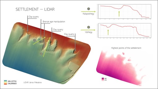
In 2025, LiDAR surveys were carried out at the site and its immediate surroundings with the collaboration of János Mészáros (Institute for Soil Sciences, HUN-REN Centre for Agricultural Research). The results suggest that the two elevations known as Várhegy and Kalapos-hegy may have been at least partly separated from the area identified by the magnetometer survey through artificial modifications of the landscape.
These observations raise the possibility that the two prominent elevations formed part of a larger, integrated settlement complex during the Bronze Age, rather than representing entirely separate archaeological entities.
Interpretation of the LiDAR data after a presentation given at the Early and Middle Bronze Age in Central Europe conference, Stará Lesná, October 2025.
The most recent investigations were carried out in the spring of 2026, when ground-penetrating radar (GPR) surveys were conducted in two sample areas to examine in greater detail the buildings previously identified through magnetometer surveys. The aim of the measurements was to determine more precisely the extent, structure, and state of preservation of these buildings. The method provides an opportunity to evaluate the remains of burnt houses by incorporating depth-related information into the analysis.
These investigations have contributed not only to a better understanding of the internal organisation of the settlement but also to the study of the Bronze Age settlement network of the Tápió Valley. Based on the available evidence, it is likely that Várhegy and Kalapos-hegy were not isolated settlements but formed part of a densely inhabited landscape in which settlements, associated cemeteries, and neighbouring sites were closely interconnected. The combined study of the cemetery remains known from Tápióbicske and the nearby hilltop settlements offers new opportunities for reconstructing the settlement structure and social relationships of the region’s Bronze Age communities.
The surveys were carried out by Adrián Berta, Ákos Ekrik, Viktória Kiss, Ágnes Kolláth, Bianka Kovács, Gabriella Kulcsár, Tibor Marton, Eszter Melis, Klára P. Fischl, Máté Szabó, and Nóra Szabó (Institute of Archaeological Sciences, Eötvös Loránd University), János Mészáros (Institute for Soil Sciences, HUN-REN Centre for Agricultural Research), and János Gábor Tarbay (Department of Archaeology, Hungarian National Museum, HNMPCC). The work was further supported by students of the Institute of Archaeological Sciences, Eötvös Loránd University: Nikoletta Dienes and Ákos Zemjánszki.
The research has also received support from the Municipality of Tápióbicske.